Loading...

D-RTK 2

ເສົາບອກຕຳແໜ່ງ
New
NewDJI

D-RTK 2

ເປັນໂຕຊ່ວຍເພີ່ມຄວາມແມ້ນຢຳໃນການບອກຕຳແໜ່ງ ສຳລັບເຮັດແຜນທີ່ ເປັນຕົ້ນ

ຄ່າຄວາມຄາດເຄື່ອນປະມານ 2 cm

ສາມາດໃຊ້ງານຮ່ວມກັບໂດຣນ DJI Phantom 4 RTK ,DJI Phantom 4 Multispectral , DJI Matrice 300 RTK DJI MG-1P RTK

ສະແດງຄ່າທີ່ໄດ້ຈາກໂດຣນ ແບບ Real-Time

ເຂົ້າເຖິງລະບົບ GPS, GLONASS, Beidou & GALILEO

ເຊື່ອມຕໍ່ 4G, OcuSync, Wi-Fi & LAN

ວັດສະດຸເຮັດມາຈາກ Carbon Fiber ແຂງແຮງ ທົນທານ

ຄ່າ IP65 ກັນນ້ຳ ແລະ ຝຸ່ນ

ພາຍໃນປະກອບດ້ວຍ IMUs Monitor Movement

ເສົາບອກຕຳແໜ່ງ
ອຸປະກອນເສີມ (ຊື້ເພີ່ມ)

Social media:

Features

Image

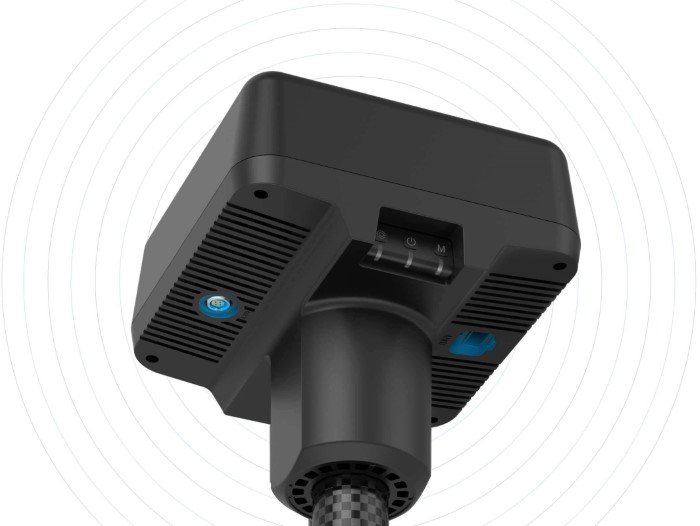
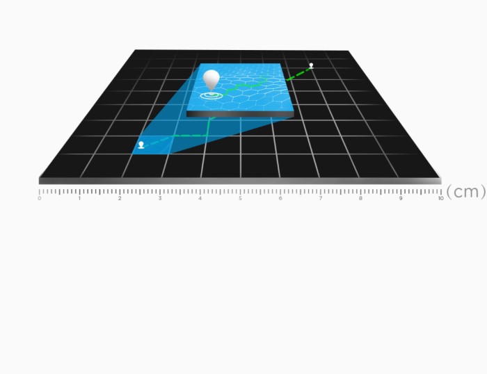
Centimeter-Level Positioning

D-RTK 2 Mobile Station fully supports GPS, GLONASS, Beidou, and GALILEO signals. Easy and quick to set up, the D-RTK 2 Mobile Station provides real-time differential data for drones to achieve centimeter-level positioning accuracy. The built-in high-gain antenna offers better signal reception from more satellites even when obstructions are present.

Image

Stay Connected for Any Mission

D-RTK 2 Mobile Station supports communication via 4G, OcuSync, WiFi, and LAN, ensuring uninterrupted, stable data transmission under any application scenario. Up to 5 remote controllers* can be connected to the D-RTK 2 Mobile Station simultaneously when used with DJI Agras drones, the Phantom 4 RTK, or the P4 Multispectral. When used with the Matrice 300 RTK, it can be connected to multiple aircraft, making coordinated operations involving multiple drones a possibility and significantly improving efficiency.

Image

Durability You Can Trust

Featuring IP65 level ingress protection and a lightweight carbon fiber body, the D-RTK 2 Mobile Station is ultra-portable and up for any task, no matter how tough. The built-in IMUs monitor movements and calibrate the tilt sensors to alert the operator of any abnormalities during the mission, minimizing risks.

Image

A Comprehensive Solution

The D-RTK 2 Mobile Station is compatible with Phantom 4 RTK, P4 Multispectral, MG-1P RTK, Agras T16, Agras T20, Matrice 210 RTK V2 and Matrice 300 RTK*. It also supports DPS (DJI Positioning Service), which provides high precision positioning data within the cover range of the base station, making it the ideal tool for surveying, aerial inspections, agriculture, and other industrial applications.


DJI Agriculture D RTK 2 Planning Field Tutorial

Learn how to use the D-RTK 2 Mobile Station as a handheld mapper to add waypoints to plan a spraying mission.